(1)15 ms unknown range
image text translation
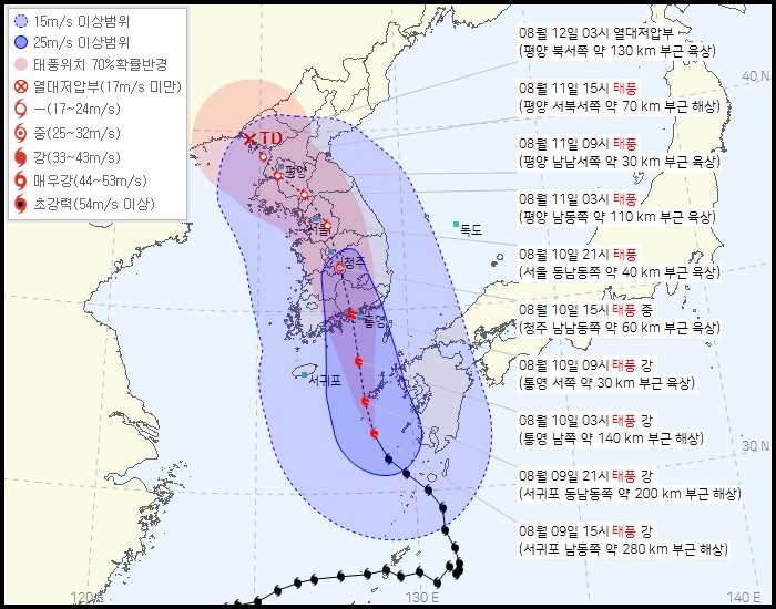
(2)August 12 at 03:00 Tropical Depression
(3)25 ms unknown range
(4)Land and land about 130 kilometers northwest of Pyongyang
(5)Typhoon location 70 probability radius
(6)Tropical Depression Less than 17ms Typhoon at 15:00 on August 11
(7)the sea about 70km west-northwest of Pyongyang
(8)Medium 25 to 32 ms
(9)August 11th, 9 o’clock typhoon
(10)River 33-43ms land about 30km southwest of Pyongyang
(11)6 Very Strong 44–53 ms
(12)August 11 at 03:00, Typhoon Super Strong 54ms Unknown
(13)Land and land about 110 kilometers southeast of Pyongyang
(14)August 10th 21:00 typhoon
(15)Land and land about 40 kilometers southeast of Seoul
(16)August 10th, 15:00 during typhoon
(17)Track and field about 60km southeast of Cheongju
(18)August 10th at 09:00, Typhoon Kang
(19)Land and land about 30km west of Tongyeong
(20)August 10th at 03:00, Typhoon Kang
(21)Sea about 140km south of Tongyeong
(22)August 9th 21:00 Typhoon Kang
(23)Sea about 200km southeast of Seogwipo
(24)August 9th at 15:00, Typhoon Kang
(25)Sea about 280km southeast of Seogwipo
Tangeumdae Terrace in Tongyoung, Hansando Island, Hanyang, Pyongyang, Uiju
Imjin War Seonjo Run Course